
Most pages on this website will include snippets of the 1890s series of USGS 15 minute quadrangles with annotations. A few pages, like this one, represent locations along the line where the location has changed so radically that a comparison with a more modern map is appropriate. Thus, this page includes both the 1894 and 2021 maps.
The Atwell Ave depot [sp] was located on Atwells Ave (one of the main roads through the historic Federal Hill neighborhood) with the station house just level with the bridge over the rails and staircases down to track level. This can be seen on Edward Ozog's website and in the collection of photographs he donated to the Providence Public Library. Despite it being a mainline station, I'm including it here because it appears on my March, 1913 timetable as a stop for a Plainfield bound train and two Washington, RI bound locals. I also think it serves a role on this site because it's the first of 3 sites we'll explore by buying a ticket on an MBTA Providence Line train. The train doesn't stop at Atwell Ave (indeed, that station no longer exists, with US-6 being carved through its location) but since it comes from the modern Providence station and not Providence Union Station, Atwell Ave is the first Hartford, Providence, and Fishkill station site that has modern trains going through it.
I've included some modern and vintage ephemera from train service in this section of the line as the first photos. After that, like on all the pages on this site, photos will proceed westward from Providence Union Station.
Click on the thumbnail for the full resolution image
| Previous Section |
Providence Union Station |
 |
A
timetable for Train 815 of the MBTA Providence Line as it appeared in
December, 2023. I chose to board this train at Attleboro, MA and take
it to Wickford Jct, RI. The logic behind that itinerary is that
Attleboro has available, cheap parking and it allows you to ride
through the Boston Switch, the abandoned Pawtucket/Central Falls
station, the yards north of PVD, and the new PVD station as well as
touring this segment of the HP&F. Since the train is a shuttle to
Wickford Junction, taking it all the way and simply staying on it to
return is the most relaxing way to make this trip. Past Cranston, there
are some nice ocean views as well. |
 |
My digital tickets for the trip (12/2023.) |
 |
Our locomotive for the trip, MBTA № 2015, an MPI MP40PH-3C. These were built in 2013-2014. It is shown here at the tail end of northbound train №
826, which was our northbound return train using the same equipment (ie
it ran as a shuttle.) We are laid over at the modern Providence Station
(12/2023.) |
 |
Our coach for the trip, MBTA № 747, a Kawasaki BTC-4 built in 1990-1991.
We are at modern Providence Station here. To get the best trackside
views, we chose to ride on the lower level and were lucky to get a
table seat for the whole time (12/2023.) |
 |
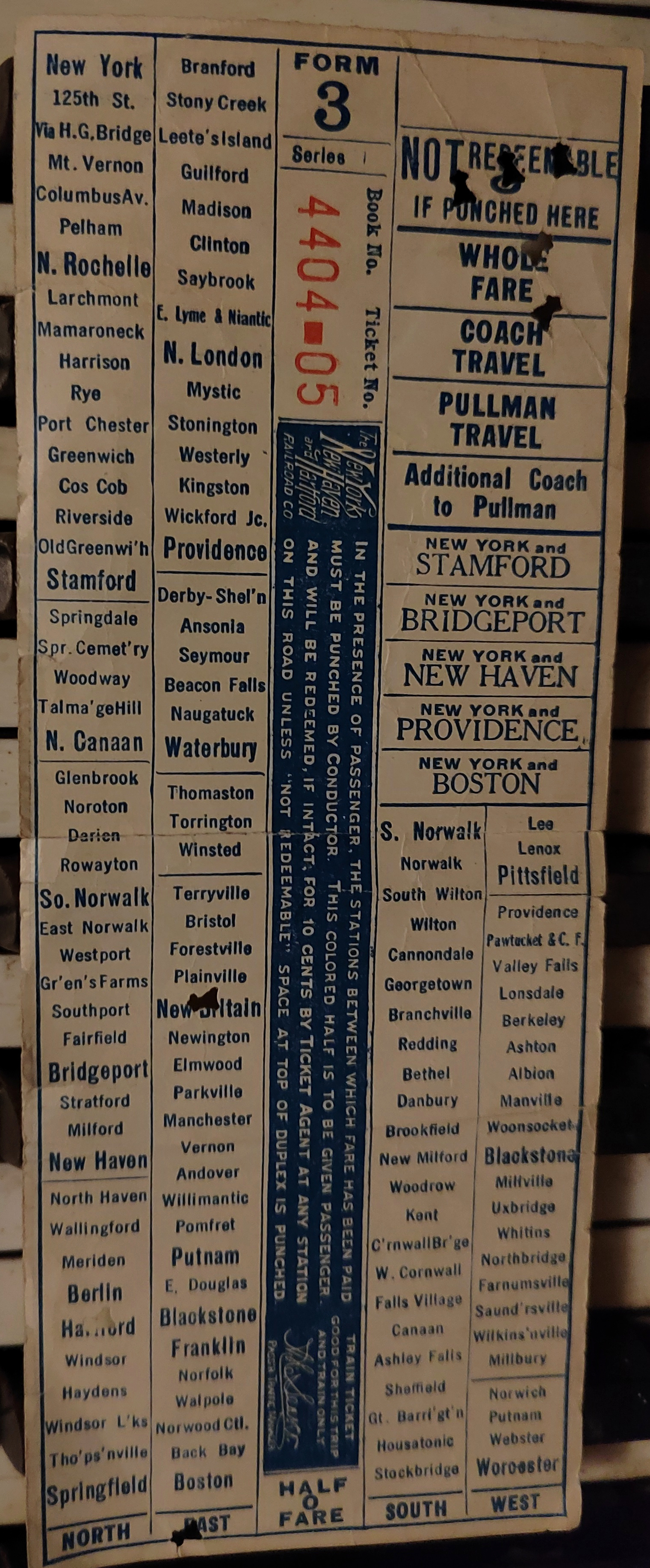
Conductor's Cash Fare Form 31
Ticket from early 20th century, showing Atwell Ave and Dike Street
stations. Notably, they are listed with the Pascoag Line stations (that
line branched off, as we shall see, in Olneyville just past Dike St)
and the other HP&F stations are absent from this ticket. It is not
known if this means this ticket dates from after the end of passenger
service, or if the HP&F local service in Rhode Island would have
been on another form. I have in my posession a Form 32 ticket from
about the same time as this and a later form 3 ticket that list HP&F stations from Waterbury to Willimantic as part of service through Putnam and Franklin to Boston. |
 |
My digital ticket for my 2023 train ride, with the QR code removed (12/2023.) |
 and 19th century HP&F (right) seat checks a conductor issues after checking tickets") |
A composite image of modern (left) and 19th century HP&F (right) seat checks a conductor issues after checking tickets. |
 |
Most of the route from the
modern Providence Station in Downtown Providence is underground, but
there is a tiny exposed section between the Providence Place Mall
(behind the camera) and the US 1 bridge where we get a glimpse of
daylight. I believe that the pinkish blur labeled 3 in this screenshot
from a video shot on northbound MBTA train №
826 might be the 1898 Union Station. The chimney on top of the Hopsital Trust Building and One
Financial Plaza (2 and 1) appear from a Google Street View atop the US
1 bridge to suggest that Union Station should be right under that
chimney. It's hard to tell. (12/2023.) |
 |
This photo, also taken from northbound MBTA
train №
826, shows the difference between the two track routings a bit more
clearly. We are under the I-95 interchange outside the Providence Place
Mall. The large brick skyscraper straight out from the camera is the
Omni Providence Hotel, which is on Memorial Boulevard. The 1981 Rhode
Island State Aerial photographs show that the old right of way was
approximately on this road. So trains to Providence Station would
essentially be running parallel in front of the Omni, had it existed at
the time (12/2023.) |
 |
A final glance back to downtown
Providence and the divergence of the two right of ways. We are east of
the Dean St bridge and looking east towards downtown and the ramps to
Interstate 95 from US 6, which is parallel to us. Clearly visible are
the brick Omni Hotel, and as stated above, the old tracks ran parallel
to its left facade here. In the distance is the spire of the Industrial
National Bank Building (the Superman building.) This is significantly
to the south of the tracks, as they would have curved north (to the
left) blocks in front of that building. (12/2023.) |
 |
Looking north of the railroad tracks between the downtown stations and the Dean St Bridge. The near building is the former Standardized Wholesale Liquor Building at 115 Harris Ave, which Providence
based ArtInRuins.com, a preservation organization, notes has appeared
on the Providence Preservation Society's Top Ten most endangered sites
twice in the last few years. In the distance is the former HP Hood plant, currently owned by the Providence Journal. This building features heavily on Edward Ozog's mainline Providence railroad website, and is a useful landmark in linking the past and present. This photo was from Wickford Junction bound MBTA Train №
815 (12/2023.) |
 |
A closer view of the HP Hood
plant, looking north from Wickford Junction bound MBTA Train № 815. The
Dean St. overpass is visible (12/2023.) |
 |
Looking
towards the southeast at the Dean St Overpass. Route 6 is on the
viaduct above us. This is from Boston bound MBTA Train №
826 (12/2023.) |
 |
Narragansett Electric and Twin City Supply. Looking north from Wickford Junction bound MBTA Train № 815 (12/2023.) |
 |
A
view looking north from Wickford Junction bound MBTA Train № 815 of the
old factory at 295 Harris St now housing the Ajay Land Company. They
rent this space as artist studios. Just behind this building is the National Register of Historic Places listed Nicholson File Company Factory. (12/2023.) |
 |
A view of the spur that used to
serve the Nicholson File Company and 295 Harris St. Although access to
both of those buildings is blocked, a small fenced in yard still seems
to exist and the connection to the Northeast Corridor seems active.
(12/2023.) |
 |
Looking south and up at the Federal Hill neighborhood from northbound MBTA train № 826 (12/2023.) |
 |
A view of the Atwells Ave overpass looking northwest from Wickford Junction bound MBTA Train № 815 (12/2023.) |
 |
The same as above, but just south and west of the Atwells Ave overpass (12/2023.) |
 |
A vintage view of the Atwell Ave station. This was donated to the Providence Public Library by Edward Ozog, and on his website he explains that this is looking back to the north at the Atwell Ave overpass. This area simply doesn't exist today- as the photograph entry at the library says, this was
at the intersection of Ridge St and Atwells Ave. Modern Ridge St
doesn't intersect Atwells Ave, because the Route 6 freeway seen
parallel to the tracks in the modern photos has removed several city
blocks. Today it terminates at Swiss Street, a full block away. In the
background, we can see the belltower of the Holy Ghost Church (12/2023.) Licensed under a Creative Commons Attribution-ShareAlike 4.0 International License. |
 |
A similar view to the above photo, showing where the station would have been. This is taken from northbound
MBTA
train №
826 and is looking to the south and east at the modern Atwells Ave
overpass of both the tracks and the US 6 freeway. The magenta X marks
approximately where the station was. In the background is the Holy
Ghost Church. On the 1939 State of Rhode Island Aerial Photos,
there's almost a full city block between this church and the cut,
because the US 6 freeway wasn't there. For this reason, if the Atwell
Ave station existed today, it would be dangling off the middle of the
modern overpass, with tracks on one side and freeway on the other.
(12/2023.) |
 |
A look back at the Atwell Ave
Station Site and Holy Ghost Church from slightly further south. This
photo was worth incuding because it includes the full church belltower,
which we can see in Mr. Ozog's vintage photo. This shows just how much
of the city the freeway carved away (12/2023.) |
 |
A final way to approximate the
former Atwell Ave station location. The blue house and the brick
building on the ridge above the freeway are on Ridge Street. We are
looking at their backs, imagine that the road in front of them
continued to run straight to the middle of the Atwells Ave overpass.
That represents the piece of the neighborhood that is missing (12/2023.) |
 |
A view of 460 Harris Ave "The Box Office," a building made of shipping containers (12/2023.) |
 |
The timetable for northbound return train 826, from which about half the photos above were taken (12/2023.) |
| Next Section |
Dike Street Station |
Return to Hartford, Providence, and Fishkill Railway Index
(c) 2016-2024 Timothy M Dowd. Last Modified @ 15:40 EDT on 2024-07-08
Made with KompoZer v0.8b3 (20081229)