
Dike Street Station is the second and final HP&F stop that still has Northeast Corridor passenger rail going through it. Our next stop, Arlington, is after the HP&F parts ways with the Northeast Corridor a bit further up the line. This stop served the Waterman-Weybosset Mill. It was also where the Providence and Springfield, also called the Pascoag Line, diverged from the HP&F tracks. At the junction with the Pascoag branch the 1939 RI State Aerial photos show a yard, which Edward Ozog calls the Olneyville Team yard. More information and a vintage photograph can be found on his site, here.
Click on the thumbnail for the full resolution image
| Previous Section |
Atwell Ave |
 |
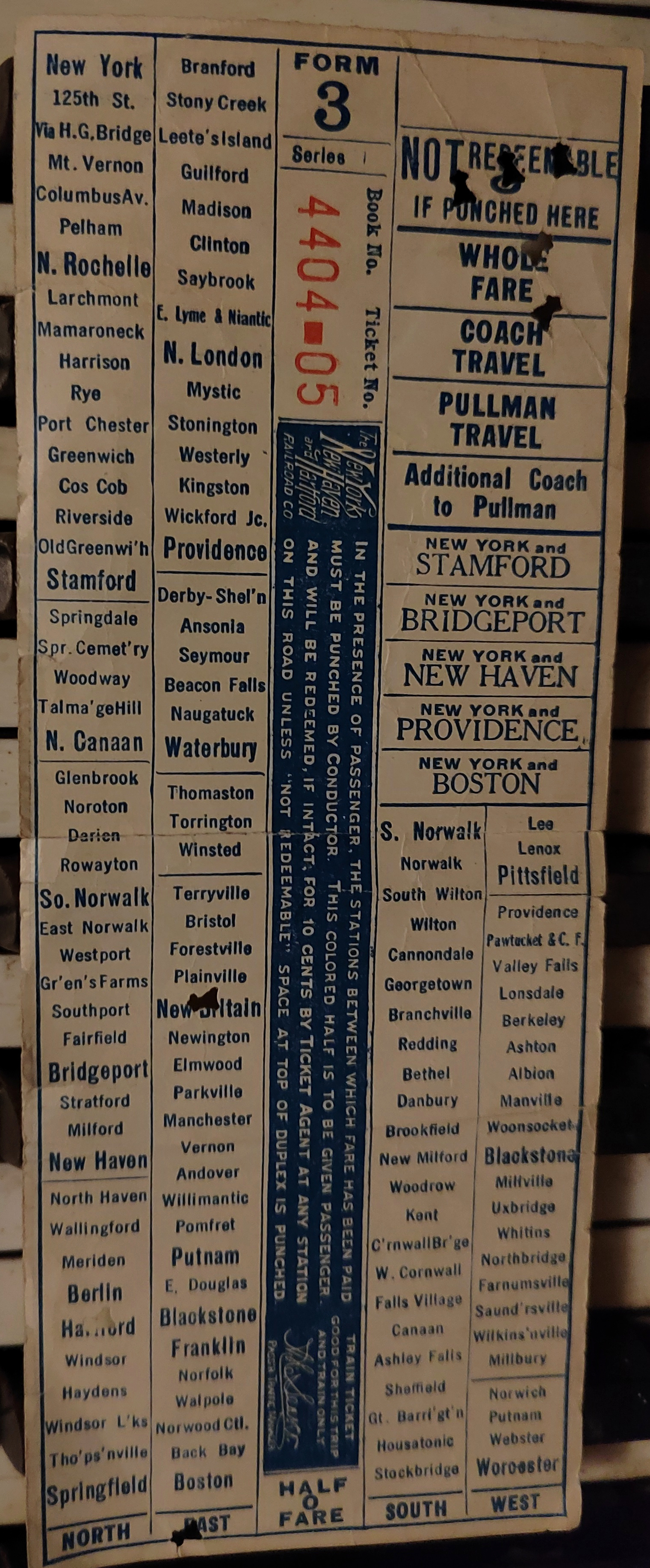
Conductor's Cash Fare Form 31 Ticket from early 20th century, showing Atwell Ave and Dike Street stations. Notably, they are listed with the Pascoag Line stations (that line branched off, as we shall see, in Olneyville just past Dike St) and the other HP&F stations are absent from this ticket. It is not known if this means this ticket dates from after the end of passenger service, or if the HP&F local service in Rhode Island would have been on another form. I have in my posession a Form 32 ticket from about the same time as this and a later form 3 ticket that list HP&F stations from Waterbury to Willimantic as part of service through Putnam and Franklin to Boston. |
 |
The Northeast Corridor Tracks past the Dike St. Station Site. I am not entirely sure why the near track is at a lower level, but this page on Senator Reed's website might be related. There was a lot of concern about the electrification of the Northeast Corridor, and that the catenary wire would stop autoracks and other large freight cars from being used. The FRIP project was created to make sure that there were dedicated freight tracks to move such cars, and I wonder if this track was lowered for related reasons (maybe the Westminster St or other bridges were too low. (11/2023) |
 |
A vintage picture scanned by Google Books of the Weybosset Mill and Dike Street Station. This is from the 1901 book A Sketch of the Mills of the American Woolen Company and can be found on Google Books here. |
 |
Looking
across the Northeast Corridor to the site of Dike St Station. This is
shot from one of the ramps connecting Westminster St to RI-10 or
US-6 during construction in November, 2023. We are looking
directly down Dike St, from the vintage photo above the station would be adjacent to the tracks and to the left of Dike St.
Both this picture and the above picture are from similar vantage
points, with Dike Street leaving the tracks and heading west, and
that's confusing because the buildings are entirely different today
than in 1901 (11/2023.) |
 |
A view of the Dike Street
Station Site from southbound MBTA Train № 815. The station would have
been just past the yellow jersey barriers that mark the end of Dike
Street (12/2023.) |
 |
A view of the Dike Street
Station Site from southbound MBTA Train № 815. This is immediately
adjacent to the station site, as the yellow jersey barriers marking the
end of Dike Street are very near the train (12/2023.) |
 |
The site of Dike St Station, looking back towards the Weybosset Mill (11/2023) |
 |
The site of Dike St Station, looking towards the tracks (11/2023) |
 |
The site of Dike St Station, looking towards Westminster St. (11/2023) |
 |
The site of Dike St Station, looking towards Cranston. (11/2023) |
 |
These triangular buildings
occupy the railroad frontage between Dike Street and the next street
south, Oak Street. The Pascoag Branch began at Oak Street. The brick
buildings in the back don't appear in the 1939 Rhode Island State
aerial photographs, but are in the 1962 ones and and, the branch passed
in front of the and under the ramps to US 6, which are running to
the west. This photo was taken from southbound MBTA train № 815
(12/2023.) |
 |
A view of the ramps to US 6. The
Pascoag Branch curved away in front of the brick building here and
under the ramps to the west. This is from an instant later on
southbound train 815 (12/2023.) |
 |
A school bus depot in Olneyville
on the site of the former yail yard. Edward Ozog calls it the
Olneyville Team Yard, and he has photos of it available here (12/2023.) |
| Next Section |
Arlington |
Return to Hartford, Providence, and Fishkill Railway Index
(c) 2016-2024 Timothy M Dowd. Last Modified @ 15:44 EDT on 2024-07-08
Made with KompoZer v0.8b3 (20081229)