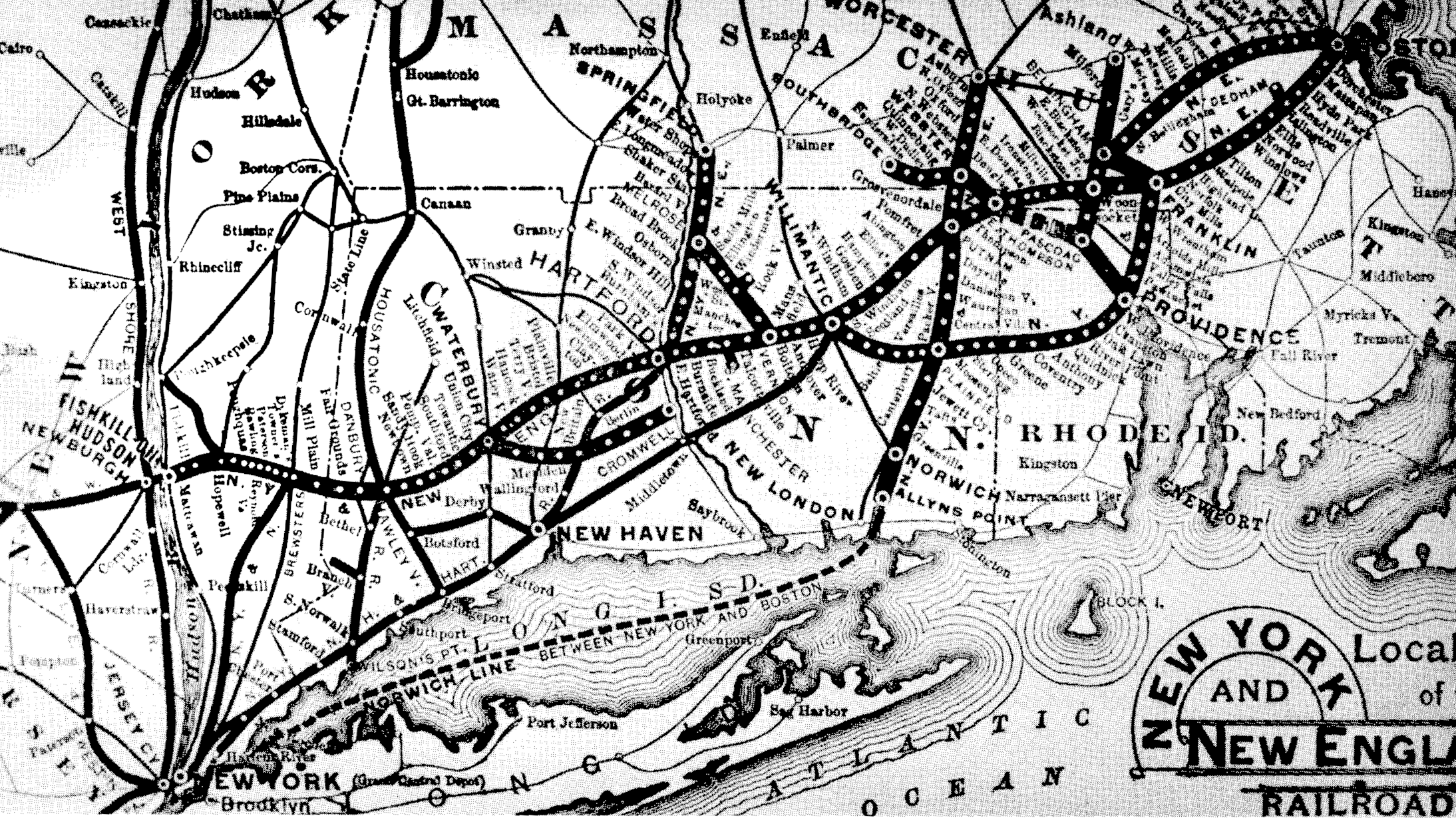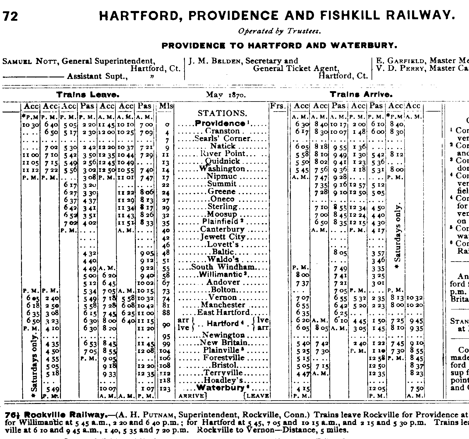


When I moved back to Connecticut in 2016, the rail line running from Providence to the Hudson River first imagined by the Hartford, Providence, and Fishkill Railway began to fascinate me. I came at this line of many regions from an eastern Connecticut perspective: I would be teaching high school in Manchester, and this was around the time when Connecticut Southern service on the Manchester Line would be ending. I found out quickly that this line was once part of a much larger vision stretching across three states, a distance of some two hundred miles. The places it once connected are today vaugely connected by the meadering US Highway 6. They have deep mutual roots, but today Providence's Federal Hill and the gentle waves of the Hudson River lapping at the shore at Beacon seem to have little in common. They once were a single train ticket away from one another.
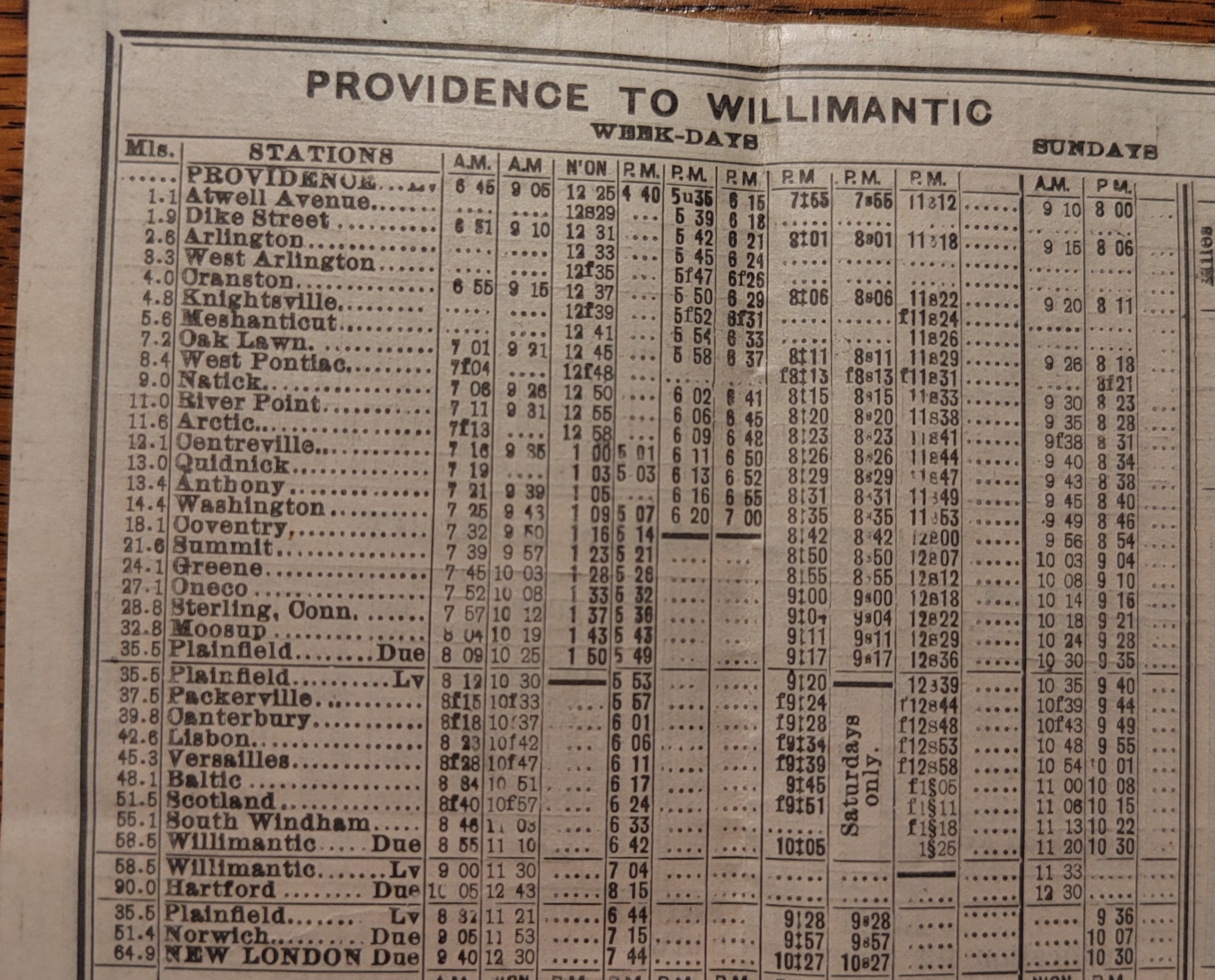
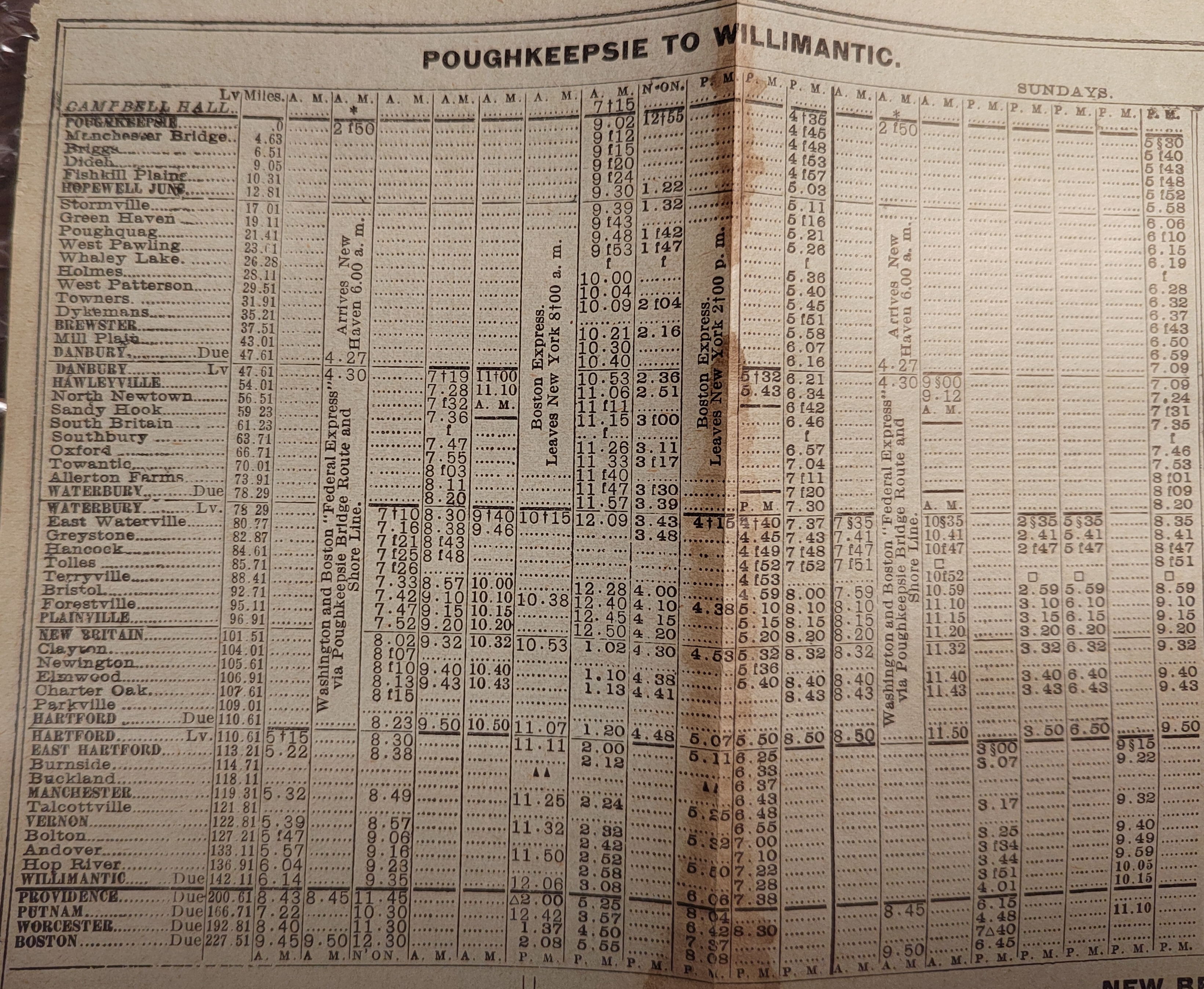
I wanted to write a story about travelling this once great railway in its entirety. But what does that mean? For starters, what is the railway even called? I began with the idea that it was the Hartford, Providence, and Fishkill of 1849, but they never made it west of Waterbury. It was under a successor, the New York & New England, that this finally occured in 1881. Where does the line go? As the advertisement above states, under the NY&NE it went to Fishkill Landing (today's Beacon, NY) but below you'll see a 1913 timetable from the successor NYNH&H that has it attached to the Maybrook line and heading towards the bridge at Poughkeepsie, NY. The same timetable shows that few trains went the whole distance, but instead operated over part of the line (ie Poughkeepsie-Hartford, Waterbury-Hartford, and a strange Danbuy-Putnam one. This last one had trains routed along the other NY&NE branch, towards Boston, east of Willimantic. Tickets from the 20th century show that the Central Connecticut stations along the HP&F kept passenger service for a very long time as part of a Waterbury-Boston route.
In short, I had to make some editorial choices. On this page, I'll refer to the line mostly as the HP&F. The exception are the stations west of Waterbury, which I'll typically call the NY&NE. Keeping with the spirit of the "Hartford, Providence, and Fishkill" I'm going to organize my photos as if the mainline runs from Providence Union Station to Beacon, NY, and treat the Hopewell Jct-Poughkeepsie part of the Maybrook line as a related spur like the South Manchester Railroad or the Rockville Branch. I'm also going to add the Dutchess and Columbia between Wicopee Junction and Dutchess Junction in as a branch. There is nothing sacred or even logical about these choices- they're just what makes the most sense to me.
What makes the line so fascinating is the various condition that the line is in. The best way to see the far eastern end is to ride the MBTA Providence Branch and the best way to see the far western end is to ride the MTA Metro-North Hudson Line Branch. In between there is a mix of rail trails, mountain bike trails, active freight rail, out of service lines, a totally abandoned part, and a section that has been converted to Bus Rapid Transit (BRT.) Photos on this site were taken on foot, on bike, on train, on kayak, and on bus. There are three excellent musuems (Connecticut Eastern, Danbury, and Hopewell Junction) and lots of ways to enjoy the line in its current state.
The site is a perpetual work in progress. I make no claims to have seen everything exciting yet, and would welcome suggestions. Across this 200 mile journey, there are many people and organizations deeply involved with their sections of the line that know far more than me. I try to link to these interesting people as much as I can in the body of the site.
To organize my discussion, I plan on using these documents. The first two are a map and timetable, scanned from Connecticut Railroads: An Illustrated History, by Gregg Turner and Melancthon Jacobus. The second two are NYNH&H timetables from March 2, 1913. The last is an NYNH&H timetable on Penney Vanderbilt and KC Jones's site that I don't have a copy of. I used that to get the milage between Beacon and Hopewell Junction.


To use these 5 documents to organize our exploring, I'll count miles from Providence and convert the Poughkeepsie-Willimantic miles using the older timetable. Note that by 1913 trains were operated separately east and west of Willimantic.
As the timetable lists Providence as mile 0 and works westward, each of the following pages will do the same (ie each picture is west of the preceeding one.)
If a place is listed here, it means we've visited. If it isn't yet linked, it means we haven't had time to organize the photos, process them, and come up with a coherent narrative of what the site currently looks like. It also might mean I don't understand what was happening at the site based on my current knowledge, and would welcome any comments.
If a place isn't listed here it means we haven't visited yet.
| Miles from Providence Union Station (1898) |
Name of Explored Site |
Features to See |
Best Means of Seeing |
| All
distances here are approximate- they come from timetables half a
century apart, bike GPS, and Google Maps. In some places they don't
line up. |
|||
| 0-0.5 |
Providence Station is north of the former Providence Union Station, so the former right of way has been redeveloped |
||
| 0 |
Providence Union Station |
on foot |
|
| 0.5-2.6 |
This section is part of active Northeast Corridor (Amtrak, MBTA, Providence and Worcester) | ||
| 1.1 |
Atwell Ave |
Northeast Corridor |
on a train |
| 1.9 |
Dike Street Station |
Northeast Corridor, remains of Weybosset Mill |
on a train, also on foot |
| about 2.4-2.7 |
Abandoned section (milage numbers are fuzzy here, but there's about 0.3-0.4 miles abandoned trackway) |
||
| about 2.6-21.6 |
Washington Secondary Rail Trail Paved in decent condition, tree roots have caused bumps | ||
| 2.6 |
Arlington |
abandoned roadbed north of Depot Ave, Beginning of Washington Secondary trail, old spur |
on foot or bike |
| 3.3 |
West Arlington |
on foot or bike |
|
| 4 |
Cranston |
on foot or bike | |
| 4.8 |
Knightsville |
on foot or bike | |
| 5.6 |
Meshanticut |
on foot or bike | |
| 7.2 |
Oak Lawn |
on foot or bike | |
| 8.4 |
West Pontiac |
on foot or bike | |
| 9 |
Natick |
on foot or bike | |
| 11 |
River Point |
Bradford Soap Plant and Trestle over South Pawtuxet River, Old Caboose, paved path |
on foot or bike |
| 11.6 |
Arctic |
Interesting mills, river views, stone walls |
on foot or bike |
| 12.1 |
Centreville |
Interesting mill, millstones, stone walls |
on foot or bike |
| 13.0 |
Quidnick |
Bridge remains, trestle |
on foot or bike |
| 13.4 |
Anthony |
Anthony Mill, old bridges, extant rail sidings |
on foot or bike |
| 14.4 |
Washington | Extant rail siding, switching equipment |
|
| 18.1 |
Coventry Center |
Coventry Center Station, Route 102 bridge, paved path |
on foot or bike |
| 21.6 |
Summit |
Rough, moguled roadbed, flooded roadbead | |
| 21.6-26.2 |
Future secton of Washington Secondary. Currently right of way is clear, but in poor condition | ||
| 24.1 |
Greene |
Rough, moguled roadbed, new trestle over Buck's Horn Brook, Greene Station Site, Greene Station. |
on foot or mountain bike |
| 26.2 |
RI/CT State Line | ||
| 26.2-33 |
Moosup Valley State Park Rail Trail. Some sections paved and others dirt, improvements ongoing in 2023 | ||
| 27 |
Oneco |
Roadbed
in varying condition, from flooded to rough moguled to new graded to
paved. There is a new bridge over Providence road that uses the old
abutments, including one with a stone culvert. The junction of the
former spur to the Oneco Quarry is easy to find and walkable to huge
abutments for a bridge across the Moosup river. |
on foot or bike |
| 29 |
Sterling |
viaduct with culvert, milepost, new improvements |
on foot or bike |
| 33 |
Moosup |
Paved
rail trail, old eastern bridge open to the public. Route obliterated in
the village, some of old western bridge still extant. The line is
totally abandoned west of the western bridge until a significant way
past Route 12. |
on foot |
| 33-35 |
This section appears totally abandoned and is under the control of CT DOT. |
||
| 35-58.5 |
Active Rail -Providence and Worcester's Willimantic Line. Milepost zero is at Plainfield |
||
| 35 |
Plainfield |
The
line is totally abandoned from Moosup to the Rawson Quarry. Past this
is the start of active Providence and Worcester Trackage. Site of
Plainfield Junction Depot |
car |
| 38 |
Packerville |
RR crossing, Butts Bridge Rd Overpass |
car |
| 40 |
Canterbury |
Aspinook Pond/Quinebaug River, trestle, station site |
car and kayak |
| 45 |
Versailles |
Stone Arch Bridge, Station Site and abandoned paper mill spur |
car |
| 48 |
Baltic |
station foundations, Rte 97 crossing |
car |
| 51.5 |
Scotland |
Station site, bridge over Merrick Brook |
car |
| 55 |
South Windham |
Station site and siding |
car |
| 58.5 |
Willimantic |
Amtrak Platform, Willimantic
River Bridge, Connecticut Eastern Rwy Museum, Columbia Jct Roundhouse, Versailles Operator's Shanty, Willimantic River Bridge |
museum guest |
| 58.5-59.8 |
Active Rail (New England Central) and Museum trackage (Eastern Connecticut Railroad Museum.) |
||
| 59.8-60.2 |
Active Rail (New England Central) |
||
| 60.2-81 |
Hop River State Park Trail - high quality dirt | ||
| 64 |
Hop River |
Ruined Eastern Hop River Bridge (Bridge 2.53) many
telegraph poles, mile markers, Route 6 overpass, Extant Hop River
Station |
foot or bike |
| 67 |
Andover |
Modern tunnel, vintage trestle, christmas tree farm, replacement bridge over highway |
foot or bike |
| 73.5 |
Bolton |
dramatically steep cuts, tunnel under highway |
foot or bike |
| 78 |
Vernon |
junction with Rockville Branch, 1849 road tunnel, remains of turntable and water tower, excellent curation of artifacts |
foot or bike |
| spur |
Rockville Branch |
well maintained rail trail |
|
| 79 |
Talcottville |
well maintained rail trail, structure remains, remains of 2nd track |
foot or bike |
| 81-86 |
Out of Service Tracks (Connecticut Southern) | ||
| 81 |
Manchester |
Ruined Platforms, current head of Out of Service Manchester Branch, junction with South Manchester Railway, abandoned track |
foot or bike |
| spur |
South Manchester Railway |
High quality dirt hiking path, currently all the way to Center Street |
foot or bike |
| 83 |
Buckland |
Buckland Depot |
car |
| 86 |
Burnside |
School Street Crossing (end of OOS segment) | car |
| 86-89.5 |
Active Rail (Connecticut Southern) | ||
| 88 |
East Hartford |
Junction with Amory Branch, Small Yard |
car |
| 89.5-90 |
Active Rail (Amtrak, CTRail Hartford Line) |
||
| 90 |
Hartford |
Union Station |
foot |
| 90-99 |
CTfastrak Bus Rapid Transit (BRT) | ||
| 92 |
Parkville |
bus, foot |
|
| 93 |
Charter Oak |
bus, foot |
|
| 94 |
Elmwood |
Elmwood Fastrak Station |
bus |
| 95 |
Newington |
Newington Depot, Newington Junction Fastrak Station |
bus |
| 97 |
Clayton |
hiking/biking paved trail adjacent to bus corridor |
bus, foot, or bike |
| 99 |
New Britain |
Downtown New Britain Fastrak Station, Active Rail |
bus |
| 99-122 |
Active Rail (Pan-Am Southern- operated by Berkshire & Eastern) |
||
| 104 |
Plainville |
Diamond with the Canal Road, Plainville Yard, active rail |
car |
| 106 |
Forestville |
Forestville Depot, active rail |
car |
| 108 |
Bristol |
Main Street Bridge, station site, active rail |
car |
| 112 |
Terryville |
tunnel route, active rail |
foot |
| spur |
Terryville (loop station) |
Original Station on spur (which was former mainline) |
car |
| 115 |
Tolles |
station site, bridge abutments, active rail |
car |
| 120 |
East Waterville |
station site, road bridge, large viaduct and culvert, active rail |
car |
| 122 |
Waterbury |
Waterbury Union Station, interesting bridges |
train, car |
| 122-126 |
Abandoned. Rails are intact in many places in Waterbury but most bridges have been removed. |
||
| 126-136.3 |
Larkin State Park Trail (State Bridlepath) - high quality dirt rail trail | ||
| 127 |
Allerton Farms |
remains of huge trestle, Hop Brook viaduct, small culvert, interesting viaducts and cuts |
foot, bike, horse |
| 129 |
Bradley's |
bridge abutment, viaduct |
foot, bike, horse |
| 131 |
Towantic |
lakes, rock cuts |
foot, bike, horse |
| 134 |
Oxford/Southford |
well maintained rail trail, viaduct, amazing stone arch over Eightmile Brook |
foot, bike, horse |
| 136.3-147 |
Abandoned. Some impressive architecture remains, like the abutments over the Pomperaug and Housatonic Rivers |
||
| 137 |
Southbury |
very little, on or near the I-84 right of way |
car |
| 139 |
South Britain |
very little at station site, on or near the I-84 right or way, replica station (offsite), bridge abutments over Pomperaug River |
car |
| 141 |
Sandy Hook |
abandoned right of way, remains of trestle over Lake Zoar, bridge abutment |
car |
| 144 |
North Newtown |
bridge abutment |
car |
| 147 |
Hawleyville |
tunnels |
foot |
| 147-159 |
Active Rail (Housatonic Railroad) | ||
| 153 |
Danbury |
Danbury Union Station, Danbury Railway Museum |
museum guest |
| 157.5 |
Mill Plain |
depot moved to Danbury Railway Museum |
on foot and museum guest |
| 159 |
CT/NY State Line |
||
| 159-188 |
Out of Service Tracks- abandonment in progress (Metro North Beacon Line) & Empire State Trail With Rail. |
||
| 169 |
Towners |
"crooked" bridge over Metro North Harlem line, wildlife refuge, station site, stone culvert, remains of Maybrook Line |
foot or bike |
| 188 |
Hopewell Junction |
split of Metro North Beacon Line and Empire State Trail, depot, NYNH&H tower, museum, caboose |
car, foot, bike, museum guest |
| spur |
Maybrook Line to Poughkeepsie |
Poughkeepsie Bridge, now open as "Walkway over the Hudson" |
foot or bike |
| 188-201 |
Out of Service Tracks- abandonment in progress (Metro North Beacon Line.) |
||
| 194 |
Fishkill Village |
Old Main St Crossing, Route 9 Crossing, station site |
car |
| 198 |
Matteawan |
former station |
car |
| 199 |
Wicopee Junction |
NY&NE tracks (critically endangered) D&C right of way |
foot |
| spur |
former D&C line to Dutchess Jct |
ruins of Tioronda Bridge, station site |
foot, train |
| 201 |
Beacon (Fishkill Landing) |
park at former docks, abandoned rail, junction with Metro North Hudson Line at RIVER switch |
train, foot, kayak |
Important Links:
USGS Historical Maps
Google Maps
Google Earth
Edward Ozog's Rhode Island Rail Lines Site
MBTA Providence Line
Washington Secondary
Tyler City Station- catalog of all Connecticut train stations
Moosup Valley State Park Trail
Providence & Worcester Railroad
Connecticut Eastern Railroad Museum
Hop River State Park Rail Trail
Vernon Rail Trail
Connecticut Southern Railroad
CTFastrak Busway
Berkshire & Eastern (Pan Am Southern) Railroad
Larkin Bridlepath State Park Trail
Housatonic Railroad
Joe Brennan's Danbury Railroads
Danbury Railway Museum
Empire State Trail
Hopewell Junction Museum
Penney Vanderbilt and KC Jones All About Railroads
Dutchess County Aerial Photos
--
back to tim's page
(c) 2016-2024 Timothy M Dowd. Last Modified @ 23:50 EDT on 2024-07-08
Made with KompoZer v0.8b3 (20081229)